A guide to OpenStreetMap in Lumion 11 Pro
In Lumion 11 Pro, the OpenStreetMaps feature takes another leap forward when it includes beautifully detailed satellite maps. Real-world terrain, rivers, farmland are now ready to be downloaded so that you can visualize for your building location.
Why use OpenStreetMaps feature?
Since version 7 Pro, Lumion has integrated OpenStreetMap, elevation data and satellite imagery to provide rapid in-context and masterplan content to a visualization. There are some benefits of this feature, which can be refer below:
-
-
-
- Make it possible to import buildings, roads, water, green spaces, and transit infrastructure as simple 3D shapes.
- Rapidly add a whole suburb or city area to your visualization.
- Simply search for the location and download the map and satellite imagery directly into Lumion.
-
-
How to work with OpenStreetMaps in Lumion 11 Pro?
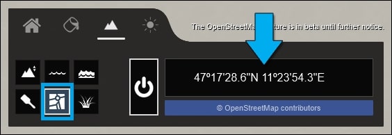
You can easily work with this feature by clicking on the OpenStreetMap button on the Landscape tab and turn the OpenStreetMap on/off button on. Then you click on the Pick GPS Coordinate button.
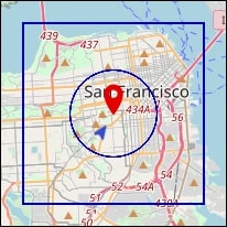
Click on the Search field to type in a place name or click anywhere on the map to place or move the GPS Coordinate pin. You can hold down the left mouse button to pan and Use the mouse scroll wheel to zoom in/out. If your scene needs a specific area to be downloaded, just simply drag the OSM range.

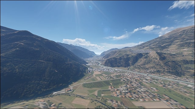
You can see example below. The square represents the 10 x 10 km Lumion Landscape. The circle is the OpenStreetMap area which will be downloaded. The triangular, blue arrow represents the camera position in your Lumion Scene. The red marker corresponds to 0,0,0 in Lumion (the red, green and blue axis origin).
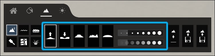
There are buttons you should notice:
-
-
-
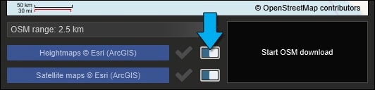
- Download Heightmaps button to include elevation data for the Lumion Landscape
- Download satellite maps button to include satellite imagery for the Lumion Landscape
- Start OSM Download button to download the chosen area and wait for the download process to finish. Download and finalization speeds are dependent on Map Range (size), your location and your local connection speeds.
-
-
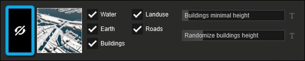
If you want to show or hide individual buildings in the OpenStreetMap model, click on the Hide Buildings toggle button like below. Then you choose a building and click on it to show or hide:
You can see above that there are other button, boxes and sliders. Here is the explaination.
-
-
-
- Preset button to select a different look for the OpenStreetMap model
- Tick boxes to show or hide water, earth, buildings, land-use, and roads
- Buildings Minimal Height and Randomize Buildings Height sliders to adjust and randomize the height of OpenStreetMap buildings that use default heights (i.e. not correct heights from the real world)
-
-
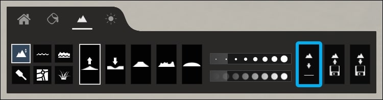
To work with the elevation data (Heightmaps), you should use the Lumion Landscape tools available on the Landscape tab.
Remove or flatten all the landscape: Once you have downloaded Heightmap data, it is retained in the Project. The Heightmap button is purely an on/off button for the download. If you want to remove or flatten the landscape, it’s very simple, just use Landscape -> Height Tools -> Flatten Landscape map
It is not possible to assign the OpenStreetMap model to one of the Layers if you wanted to control visibility. It exists on a special Lumion Layer only. So you need to turn off OpenStreetMap to fully hide the model.
Switching off OpenStreetMap before saving the Project means that the model will not be saved as a part of the .LS11 Project file.
To avoid having to download the OpenStreetMap model again, make sure you turn OpenStreetMap back on again before saving the .LS11 Project file.
Conclusion

OpenStreetMap can appear to be a normal feature to use, however, it’s very useful to optimize and visualize your own exterior scene. You can spends days to adjust your materials and textures, but don’t forget to take advantage of this feature so that your renderings looks more wonderfully photorealistic.
iRender is proud to be one of very few cloud rendering services support Lumion. With our powerful config of 1 x RTX3090, we can serve any project of yours in Lumion and boost up the rendering time to 5-10x. Register an account today to experience our service. Or contact us via WhatsApp: (+84) 916806116 for advice and support.
Thank you & Happy Rendering!
Source: lumion.com
Related Posts
The latest creative news from Lumion Cloud rendering.